
DRIVING LANES
According to the Federal Highway Administration (FHWA), converting four traffic lanes to three lanes – one travel lane in each direction with a center left-turn lane – can improve safety and traffic flow while adding benefits for pedestrians and cyclists. ¹
[1] The Federal Highway Administration found a crash reduction of 19 to 47 percent on four-to-three lane conversions.
Converting four traffic lanes to three makes the street safer by reducing vehicle conflicts and speeding. Studies have shown a 19-47% decrease in collisions on roads where the number of lanes has been reduced from four to three. The addition of a center turn lane provides a safer space for vehicles turning left from or onto the street, leading to fewer rear-end, left turn, and sideswipe crashes. Reducing the street to three lanes has also proven to lower vehicle speeds and reduce lane changes, creating a safer driving environment.
Converting four traffic lanes to three lanes can also improve traffic flow so there are fewer delays. The addition of a center turning lane can reduce delays on side streets since vehicles turning left onto the main road have fewer lanes to cross and can turn more comfortably. Reducing the speed difference between vehicles also improves traffic flow since there is less stop-and-go traffic.
Pedestrians and cyclists also benefit from reducing the number of traffic lanes. Lower vehicle speeds make the street safer for everyone. Pedestrians can cross the street more safely and comfortably since they have fewer lanes to cross and are at risk from moving traffic for a shorter length of time. Reducing the number of traffic lanes makes room to add bicycle lanes. These create more space between cyclists and moving vehicles, especially when there is a buffer or parking lane between the bicycle lane and the vehicle lane.
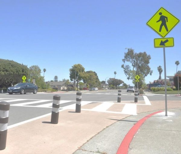
CROSSWALKS
Reducing the width, reducing lanes, and potentially adding refuge islands to a street makes it easier for pedestrians to cross for two reasons: the distance to walk is less and there are fewer lanes to cross. Increasing sight lines is another way to protect pedestrians. This is usually accomplished by painting curbs red near areas where cars can intersect other cars, such as an intersection or driveway. Keeping parked cars further away from a driveway or a crossing enables cars and pedestrians to have more space between and better sightlines to see each other. Finally, new crosswalks with Americans with Disabilities Act (ADA) ramps will ensure that all users can safely and easily cross the street. This will make it easier for people to walk to nearby parks, schools, and other neighborhood destinations.
BIKE LANES
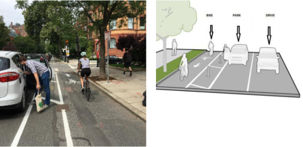
Wider, protected bike lanes would make cycling safer and more comfortable for people of various ages and abilities. Given the high traffic volumes and speeds on Rainier, a protected bikeway is recommended to protect cyclists. Both the FHWA and the National Association of City Transportation Officials (NACTO) recommend a separated bikeway for roadways like Rainier Avenue based on the street’s speed limit (35 MPH) and vehicle volume (over 6,200 vehicles per day).
Protected bikeways, also known as “cycle tracks”, are typically at the street level and use a variety of methods for physical protection from passing traffic. Cyclists may be separated from traffic by a parking lane, post, bollard, or other barrier. Protected bikeways improve safety and comfort for cyclists of all ages and abilities by dedicating protected space for cyclists to ride. They remove the risk of collisions from vehicles passing too closely to cyclists, and buffers between the bicycle lane and parking lane prevent the risk of being hit by opening vehicle doors.
¹FHWA Road Diet Informational Guide
²FHWA Bikeway Selection Guide, NACTO Urban Bikeway Design Guide