Rainier Active Transportation Improvements with Paving Project
Rainier Avenue Paving & Traffic Calming Upgrades
Project Description
This project is made possible by funding from Measure U - a community-supported revenue measure.
Creating safer streets is top priority for us here at the City of Petaluma. Since September 2021, we have been seeking community input on ways to make Rainier Avenue safer. Rainer is scheduled to receive significant upgrades from North McDowell Blvd. to Sonoma Mountain Parkway. Upgrades will include:
Replacement of water services (underground water pipes)
Pavement restoration (repaving)
Traffic, bicycle, and pedestrian safety upgrades
WHAT WE’VE DONE SO FAR
Trial Demonstration Project
In August 2022, we installed a trial demonstration project on Rainier Ave. from N. McDowell Blvd. to Maria Drive, which includes temporary elements like paint and rubber barriers. This gave the community a chance to experience proposed changes to the road and provide feedback, and for City engineers and police to gather important safety data. All of this helps inform the design of more permanent solutions.
Demonstration project elements:
Reduced traffic lanes from 4 to 3, with one lane in each direction and a left turn lane in the middle
Added a parking protected bike lane on the north side of the road
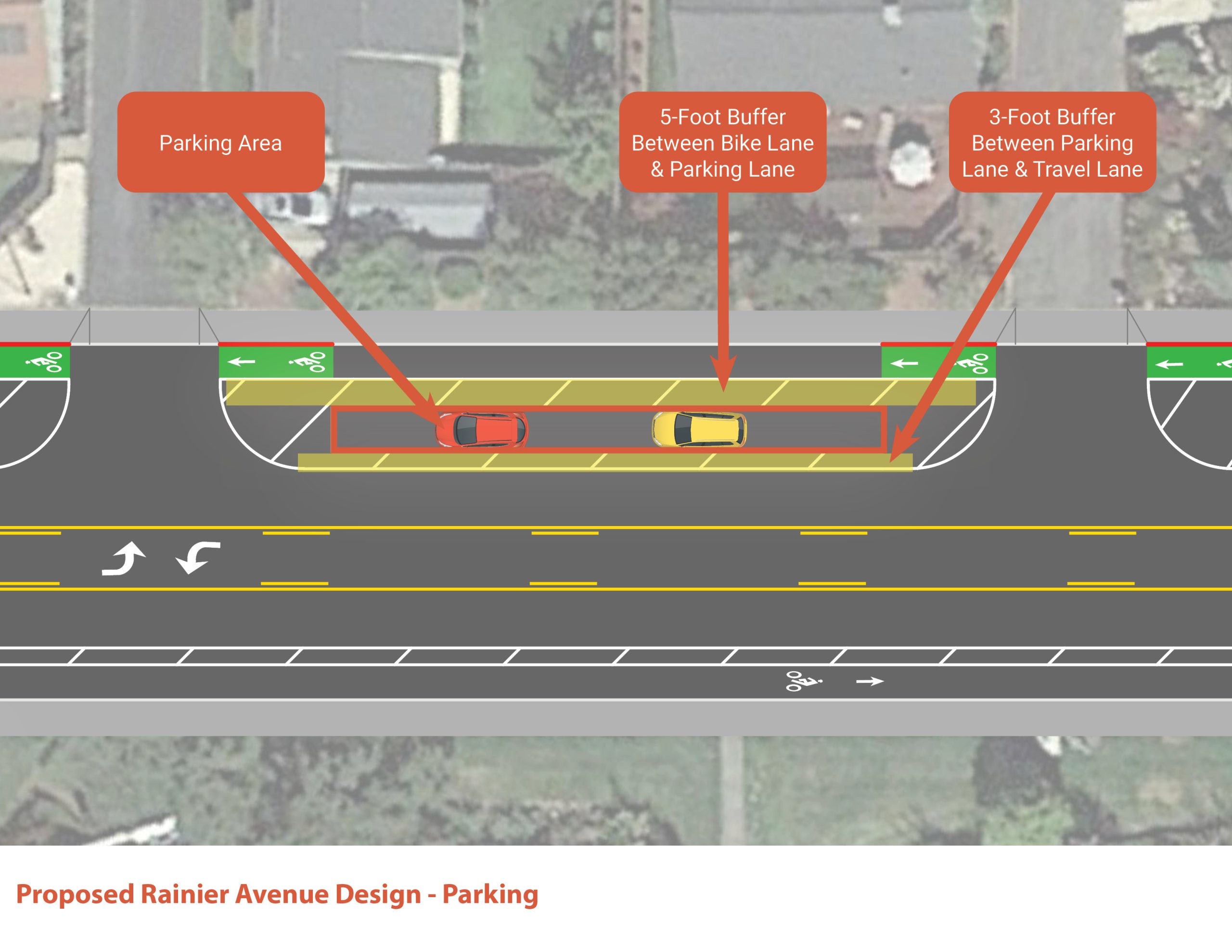
Added a 3-foot buffer between the parking lane and travel lane on north side of road
Added a buffered bike lane on south side of road (parking removed)
COMMUNITY INPUT
We have been seeking community input since September of 2021, with significant community engagement taking place before and after the installation of the demonstration project. Outreach has included:
Mailers
Virtual Community Workshop
Website form
Neighborhood Meeting
Social media posts
Online surveys
Below are links to notes and videos of our Virtual Community Workshop:
CLICK HERE to view notes recapping the workshop and input from the public.
CLICK HERE to view the presentation shared during the workshop.
CLICK HERE to view the responses from the webform.
Thank you to all who took the time to engage in this crucial conversation with us. Rainier is an important road in Petaluma and our goal is to make it the best it can be for all users and residents. Your feedback is valuable tool in our process.
WHAT WE’VE SEEN & HEARD
Since the demonstration project was installed, we have tracked safety data and received feedback from the community.
Safety Data:
Demonstration Stretch (Maria Drive to N. McDowell Blvd)
72% of drivers complying with 35mph speed limit
Top speed recorded: 45mph
Non-Demonstration Stretch (north of Maria Drive)
48% of drivers complying with 35mph speed limit
Top speed recorded: 50mph
No adverse congestion impacts were observed or reported anywhere on Rainier Avenue
Community Feedback
Challenges seeing oncoming traffic when pulling out of driveways
Complaints about difficulty entering/exiting parked cars on driver’s side due to proximity of travel lane
Generally unpopular with drivers – opposition to lane reduction, unfamiliarity with new configuration
Popular with people using bicycles
Presentation to City Council
We presented safety data and community feedback to City Council as part of our Active Transportation workshop on October 16, 2023. At that meeting, City Council directed staff to “harden” or permanently install the demonstration configuration.
NEXT STEPS
Rainier is scheduled to receive upgrades to underground utility pipes (water services) in the summer of 2025. The City will also install a recycled water pipe that will supply recycled water to the parks and schools in the area.
After the utility work is complete, we will do a full road reconstruction on Rainier Avenue. This will provide a smooth road surface and give us the opportunity to install permanent safety upgrades. We will share and seek input on the final roadway design with the community as we get closer to construction, currently estimated to occur in early 2026.
We recently made updates to the current demonstration project to ensure it is easily visible until the permanent changes are installed.
Read on for details on the water services and paving work.
The project will take place on Rainier from North McDowell Blvd. to Sonoma Mountain Parkway.
Traffic Impacts & Benefits
There will be minor delays during construction. When completed, the project will help keep the road protected and ensure more extensive reconstruction will not be required in the future and will offer improved safety conditions for motorists, bicyclists, pedestrians and those with limited mobility.
Timeline/Project Status
Tentative schedule (dates subject to change):
August 2022: Demonstration Project installed & community survey launched
December 1, 2022: Survey closes
December 7, 2022: Project team presented survey results and traffic data to Pedestrian & Bicycle Advisory Committee
October 16, 2023: Project team presented survey results and traffic data to City Council
Spring 2024: Water services replacement underground work to commence
Summer/Fall 2024 (Dates TBD): Final roadway configuration to be installed following paving project
Summer/Fall 2024: Final active transportation build-out, including striping, crossings, and other bike/ped improvements to be installed immediately upon completion of paving
Council Goals and Priorities
This project reflects the following City goals, with Safe Streets/Safe Mobility being one of the top ten City Council priorities.
A CITY THAT WORKS FOR EVERYONE
Provide City infrastructure that is safe, sustainable, multi-use, efficient, inspiring civic pride.
Establish and improve paths, as useful transportation options, and make walking and biking easy, fun, and safe.
Better integrate multi-modal transportation with street designs
A SAFE COMMUNITY THAT THRIVES
Maintain and enhance public safety and prepare for emergencies and disasters, through crime and fire prevention, and traffic safety.
Implement City Vision Zero plan with a focus on pedestrian and cyclist safety with improvements to uncontrolled crosswalks, curb ramps, sidewalk, and bicycle infrastructure.
Enhance pavement management program to improve the safety and serviceability of our roads to protect drivers, cyclists, and pedestrians.
This project will help meet our Climate Action goals by allowing roadway users to feel more comfortable and safer walking and riding bikes. Also, this project helps to implement safer routes to nearby schools.
Funding
Funding is provided by California State Senate Bill 1 (SB 1), the Road Repair and Accountability Act of 2017 supported by the gas tax, and Measure U, a community-supported revenue measure.
Rainier FAQ's
Over the course of community outreach, there were some common questions and concerns that were raised. The following FAQs respond to what we’ve heard from the community. If you have additional questions or concerns, please contact project manager,Ken Eichstaedt, Senior Traffic Engineer.
According to the Federal Highway Administration (FHWA), converting four traffic lanes to three lanes – one travel lane in each direction with a center left-turn lane – can improve safety and traffic flow while adding benefits for pedestrians and cyclists. ¹
[1] The Federal Highway Administration found a crash reduction of 19 to 47 percent on four-to-three lane conversions.
Converting four traffic lanes to three makes the street safer by reducing vehicle conflicts and speeding. Studies have shown a 19-47% decrease in collisions on roads where the number of lanes has been reduced from four to three. The addition of a center turn lane provides a safer space for vehicles turning left from or onto the street, leading to fewer rear-end, left turn, and sideswipe crashes. Reducing the street to three lanes has also proven to lower vehicle speeds and reduce lane changes, creating a safer driving environment.
Converting four traffic lanes to three lanes can also improve traffic flow so there are fewer delays. The addition of a center turning lane can reduce delays on side streets since vehicles turning left onto the main road have fewer lanes to cross and can turn more comfortably. Reducing the speed difference between vehicles also improves traffic flow since there is less stop-and-go traffic.
Pedestrians and cyclists also benefit from reducing the number of traffic lanes. Lower vehicle speeds make the street safer for everyone. Pedestrians can cross the street more safely and comfortably since they have fewer lanes to cross and are at risk from moving traffic for a shorter length of time. Reducing the number of traffic lanes makes room to add bicycle lanes. These create more space between cyclists and moving vehicles, especially when there is a buffer or parking lane between the bicycle lane and the vehicle lane.
CROSSWALKS
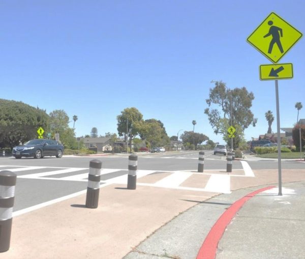
Reducing the width, reducing lanes, and potentially adding refuge islands to a street makes it easier for pedestrians to cross for two reasons: the distance to walk is less and there are fewer lanes to cross. Increasing sight lines is another way to protect pedestrians. This is usually accomplished by painting curbs red near areas where cars can intersect other cars, such as an intersection or driveway. Keeping parked cars further away from a driveway or a crossing enables cars and pedestrians to have more space between and better sightlines to see each other. Finally, new crosswalks with Americans with Disabilities Act (ADA) ramps will ensure that all users can safely and easily cross the street. This will make it easier for people to walk to nearby parks, schools, and other neighborhood destinations.
Example of a crosswalk with reduced crossing distance and improved sightlines.
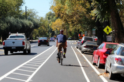
BIKE LANES
Wider, protected bike lanes would make cycling safer and more comfortable for people of various ages and abilities. Given the high traffic volumes and speeds on Rainier, a protected bikeway is recommended to protect cyclists. Both the FHWA and the National Association of City Transportation Officials (NACTO) recommend a separated bikeway for roadways like Rainier Avenue based on the street’s speed limit (35 MPH) and vehicle volume (over 6,200 vehicles per day).
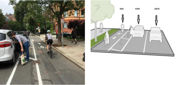
Protected bikeways, also known as “cycle tracks”, are typically at the street level and use a variety of methods for physical protection from passing traffic. Cyclists may be separated from traffic by a parking lane, post, bollard, or other barrier. Protected bikeways improve safety and comfort for cyclists of all ages and abilities by dedicating protected space for cyclists to ride. They remove the risk of collisions from vehicles passing too closely to cyclists, and buffers between the bicycle lane and parking lane prevent the risk of being hit by opening vehicle doors.
Examples of a protected bikeways. Rainier Avenue is wide enough to provide a 5-foot buffer between the parking area and the bike lanes, and a 3-foot buffer between parked cars and the westbound travel lane.
Parking on Rainier Avenue was provided along both sides of the street prior to the installation of the demonstration project. However, we found less than one-third of the curb space west of Maria Drive was occupied during peak times, and even less is occupied east of Maria Drive. To accommodate a safer road design for all users, parking is now limited to the north side of the street. Given the number of spaces that will be on the north side, we believe that there is sufficient parking to accommodate neighborhood needs. With parking on the north side of the street, additional mid-block high visibility crosswalks with median refuge islands would be installed to provide safer pedestrian and bicycle crossings for people who live on the south side of the street.
Rainier Avenue is large enough to accommodate about 40,000 cars per day. Even with a lane reduction the street can accommodate more than the total vehicles using the road now. Thus, we don’t believe people would choose to go out of their way to avoid Rainier Avenue and use nearby neighborhood streets.
Traffic volumes on Rainier Avenue are well below the threshold to support one through lane in each direction. During the peak hours, Rainier Avenue carries up to 325 vehicles in each direction, but the street’s peak hour capacity is over four times that. Reducing the number of lanes from four to three provides traffic calming while still leaving room for over 800 vehicles per hour in each direction. This is still many more vehicles than use the road today.
One of the best ways to park cars and protect cyclists is by moving cars away from the curb and putting the bike lane in between the sidewalk and the parked cars. In the demonstration project configuration, there is a five-foot buffer protecting the parked cars from the bikeway and an extra three-foot buffer protecting the parked cars (and doors) from the moving vehicle travel lane. The design alleviates the potential for car doors opening into bike lanes or sidewalks.
Another type of bike lane, “buffered bike lane” delineates space for bicyclists but does not provide a physical separation between people cycling and driving. With on-street parking, they also place the bicycle between parked vehicles and moving motor vehicles. This can feel uncomfortable for cyclists, especially on streets with multiple vehicle lanes, high traffic volumes, and high speeds. Buffered bike lanes are also “porous”, i.e., cars can cross them at any location to enter or exit on-street parking areas. This results in additional conflicts.
Protected bikeways use physical separation – such as posts or parked vehicles – to create a space that is consistently designated for cyclists. These are recommended instead of buffered bike lanes on roads where daily traffic volumes are higher than approximately 6,000 vehicles and where vehicle speeds exceed 25 MPH, such as Rainier Avenue. Physical separation makes these bikeways safer and more comfortable for cyclists of all ages and abilities regardless of the number of lanes, traffic volumes, or speeds. Protected bikeways also improve the overall organization of the street, which increases safety for people walking, cycling, and driving (NACTO).
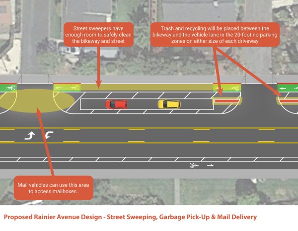
The protected bike lane is designed to allow street-sweepers to safely clean the bikeway and street. There is also ample space to place garbage bins, recycling, and yard debris in the buffer zones on either side of the driveways.
The gaps before, at, and after driveways allow mail vehicles to pull over without holding up traffic in the vehicle lanes.
Yes, street trees could be planted in the future, possibly even in some of the wider buffer areas.City staff is exploring options for tree planting and greening along this segment of Rainier and will bring recommendations for a future project to implement tree planting and greening of the corridor.
While a two-way bikeway on the south side of Rainier would not require cyclists to cross driveways, this is not the safest option for cyclists on Rainier Avenue. A two-way bikeway would create complex conflict points at heavily trafficked intersections where drivers would need to look for vehicles, pedestrians, and two directions of bike traffic before making a turn. Drivers would need to look for cyclists traveling against the flow of vehicle traffic: this is an unexpected place for cyclists to be and could lead to collisions from drivers not spotting cyclists in time, especially when cyclists must cross Rainier to turn onto a side street.
With the one-way bikeway design, drivers still need to look for cyclists in the bike lane when entering and exiting their driveways, however, the potential conflict points at driveways are less complex. This is because they have much lower vehicle volumes, vehicles are moving at much slower speeds, and they are only moving in two directions – in or out of the driveway – as opposed to intersections where hundreds of vehicles are moving in multiple directions and at varying speeds. Additionally, the fact that vehicles’ movements can be staged into two movements when exiting the driveways gives them more time to look for potential conflicts. Drivers first scan for pedestrians on the sidewalk and for cyclists in one direction before moving to the buffered area before they enter the travel lane, which would have improved sight lines under the proposed design. Here they can scan for moving vehicle traffic and make their turns safely.
We strongly believe that installing a protected bikeway in each direction, one on each side, is the safest solution because it allows cyclists to more safely travel through and across Rainier Avenue compared to a two-way bikeway. This aligns with NACTO and FHWA guidelines, which recommend one-way bikeways instead of two-way bikeways when streets are wide enough to accommodate them, where there are destinations on both sides of the street, and where there are limited connections to other bike facilities.
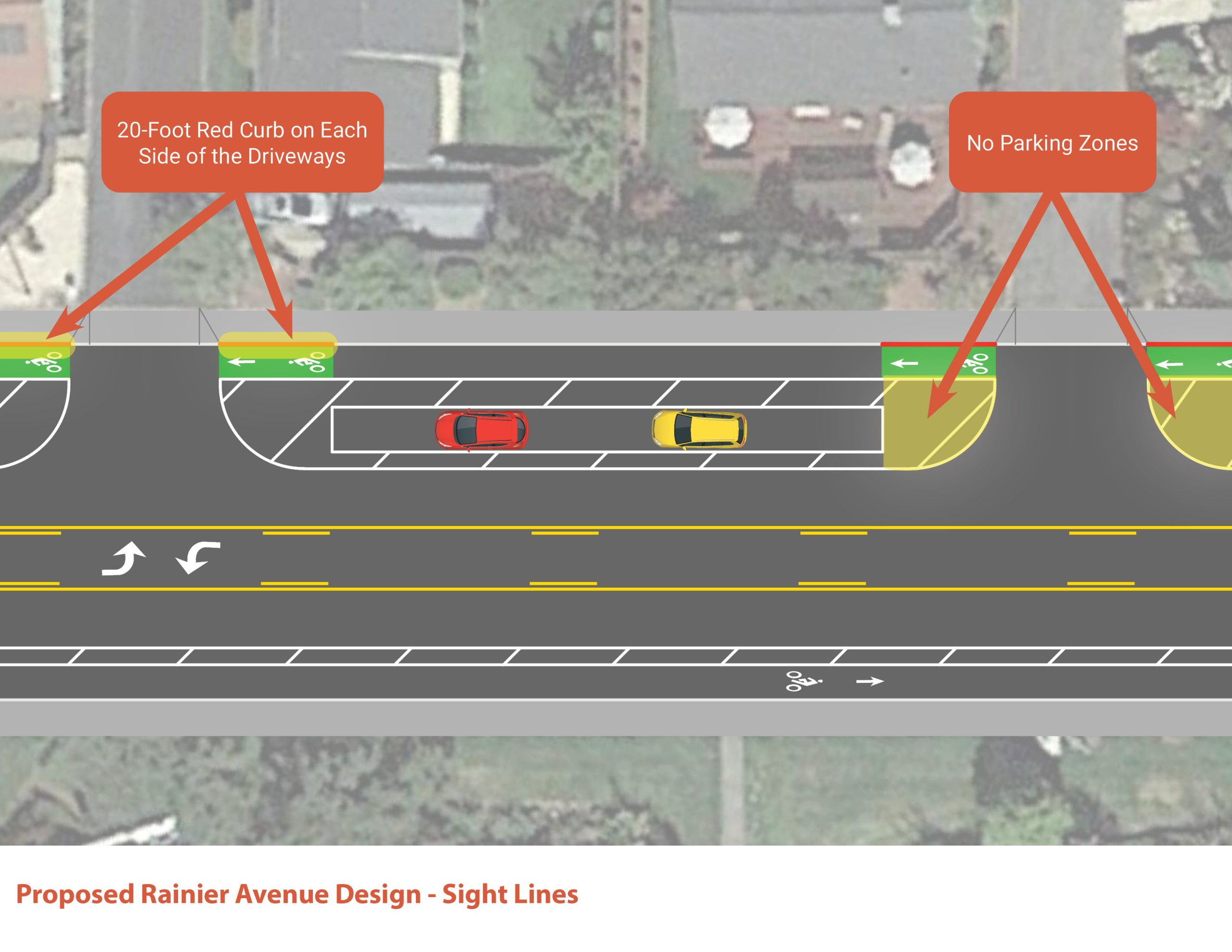
When studying the street, we realized that the driveways located along Rainier Avenue do not provide adequate sight lines for people currently exiting the driveways. To remedy this, the curbs were painted red for 20 feet on each side of the driveways. Regardless of how we decide to move forward with the repaving and repainting project, we would paint the curbs to meet safety standards.
Under the demonstration project conditions, sight lines were improved by adding 20-25-feet of red curb paint recommended by National Association of City Transportation Officials (NACTO) and the Federal Highway Administration (FHA) at driveways, giving motorists coming out of their driveways better sight lines and more time to react to oncoming vehicular traffic. Additionally, moving the bike lanes towards the curb allows drivers to first focus on pedestrians and bikes safely. They can then pull out of their driveway and focus on oncoming traffic, which will be afforded with improved sight lines. With the parking setbacks motorists entering Rainier Avenue will improve safety conditions.